
Category: Photography
Information about picture taking, aerial photography and how I do what I do.
New Website
Androken Aerial is my website to showcase my aerial images. Other than drone shots, my aerial photography days are coming to an end. However, my interest in imaging, both photography and especially videography has increased. So, I have setup a new website, androken.com to display that work.
I will keep androkenaerial.com for a while in the hopes I can find new ways to create aerial images, but most of my efforts will be found on androken.com. Enjoy!
2023 Plans
I hope to explore the mountain by airplane, drone and on foot. Well, I had hoped to use a drone, turns out Baxter State Park does not allow drones to operate from park property. Not a big deal.
Gardens Aglow
Costal Gardens Boothbay, Maine
It is good to go at the earliest, 4:00 PM entry time. The setting sun allows you to see the lights from daylight thru twilight and then night.


Abominable Abdominal
Enough said on that subject; although, I will add no more cutting. Ugh!
Reviewing my last flight for additional sunset pictures. I kind of like this one.

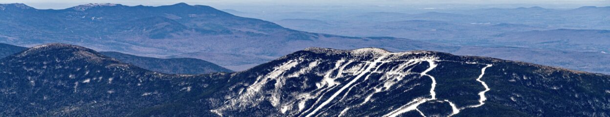
Katahdin January 2022


Not Resolutions, Just Need to Do Stuff
Get healthy! Get strong!
Redo the lighthouse portion of this website. It’s a mess, I used different image galleries, different means of displaying the pictures. Should I organize them geographically or perhaps photogenically? A few 2022 calendars were printed, but they need some supporting material such as location and history of the lighthouses.
For 2022 I had planned to aerial photograph the 14 +4K mountain peaks in Maine. I’ll work on that. My sister also suggested some sort of aerial travelogue about the Kennebec and Androscoggin Rivers. That would be fun and give me an opportunity to work on my video as well as my still photography skills.
But first, I need to get healthy and I need to get strong.
Happy New Year!
Northern Penobscot Bay
We flew up over Penobscot Bay, Maine to the Penobscot River and the Penobscot Narrows Bridge on May 15. I’ll put together a short video of the flight, but in the meantime, here is a clip of us flying over Ilseboro. Several more lighthouses on the Bay were photographed using a high rez camera and long lens.
Finished Shooting the Lighthouses along the Midcoast
Now onto Penobscot Bay
Chilly and a tiny bit bumpy, but on February 26, we finished photographing the remaining lighthouses along the Midcoast and started to shoot the Penobscot Bay lights. More good news, the FAA has restored my 2nd class medical, but I find shooting while a qualified pilot flies is much better for both flying and picture taking. So, once again, thanks Jakob for going along with me.

Looking at some of these lighthouses in the Winter, you really begin to understand why lighthouse keepers had to be tough, both physically and mentally. Often cold and remote, they were really on their own for much of the winter. Now that all the lighthouses have been automated, the keepers’ job is gone, but their legacy remains. And while the lighthouses themselves are still standing for now, when will they tumble into the sea? As you’ve seen from shots of some of the the Casco Bay lighthouses their foundations are already underwater. Perhaps these 19th Century sentinels are giving us one last warning!
Local (to me) Lighthouses
On February 11, 2021, we started to reshoot and photograph for the first time, some of the lighthouses located close to the Brunswick area. Included are Doubling Point and the range, Squirrel Point, Perkins Island, Pond Island, Seguin, Hendricks Head, The Cuckolds and Burnt Island Lights. I’m using a new camera with a much higher resolution, which is very helpful, but I have a bit of a learning curve to overcome. Thank you Jakob for the piloting assist.
